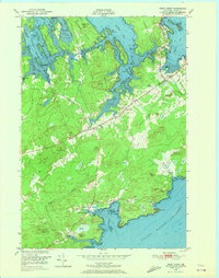
1949 Map of West Lubec
USGS Topo · Published 1972About this map
The coastal headlands of Denbow Neck and Seward Neck define this Down East landscape at the close of the 1940s. The survey illustrates a region where maritime geography dictates local life, from the deep waters of the Grand Manan Channel to the sheltered inlets of Baileys Mistake and Federal Harbor. Small rural centers such as West Lubec and North Lubec are shown connected by a network of roads that wind around extensive inland wetlands labeled simply as Heath. Genealogists and local historians can pinpoint the locations of civic foundations like the Wilcox Sch and Crow Neck Sch, alongside the West Lubec Cem. Notable landforms like Porcupine Mtn and Cobble Hill stand as prominent markers above a shoreline carved into numerous coves and points, including the distinct Jim Head and Boot Head peninsulas.
Find a feature on this map
63 named features on this map. Tap any name to fly to it.
Don’t see what you’re looking for? This feature index may not catch every label — zoom into the map to look around manually.
Map Details
Editions of this 1949 West Lubec Map
3 editions found
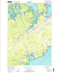
Other maps of this area

1907 · Eastport
USGS Topo · 1:48,000

1908 · Eastport
USGS Topo · 1:62,500

1917 · Cutler
USGS Topo · 1:62,500

1918 · Cutler
USGS Topo · 1:62,500

1943 · Eastport
USGS Topo · 1:62,500

1945 · Eastport
USGS Topo · 1:62,500

1949 · Whiting
USGS Topo · 1:24,000

1949 · Pembroke
USGS Topo · 1:24,000

1949 · Eastport
USGS Topo · 1:24,000

1949 · West Lubec
USGS Topo · 1:24,000