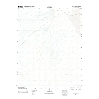
2012 Map of West of Baker
USGS Topo · Published 2012About this map
The arid drainage patterns of San Bernardino County are etched across this Mojave Desert landscape, dominated by the branching network of Salt Cr. The topography reveals a complex system of alluvial fans and desert washes that define the area west of Baker during the early 21st century. Human infrastructure is limited to long-distance corridors, most notably the path of Powerline Rd which cuts diagonally across the northern terrain. Parallel to this utility route, Silver Lake Rd skirts the northern edge of the map, providing one of the few managed access points through this stark environment. The map captures a moment of modern desert management where the vast, natural flow of dry creek beds remains the primary geographic feature, largely undisturbed by settlement or significant industrial development.
Find a feature on this map
3 named features on this map. Tap any name to fly to it.
Don’t see what you’re looking for? This feature index may not catch every label — zoom into the map to look around manually.
Map Details
Editions of this 2012 West of Baker Map
This is the sole edition of this map. No revisions or reprints were ever made.
Other maps of this area

1933 · Avawatz Mountains
USGS Topo · 1:250,000

1947 · Trona
USGS Topo · 1:250,000

1948 · Red Pass Lake
USGS Topo · 1:62,500

1948 · Trona
USGS Topo · 1:250,000

1948 · Cave Mountain
USGS Topo · 1:62,500

1951 · Cave Mountain
USGS Topo · 1:62,500

1951 · Red Pass Lake
USGS Topo · 1:62,500

1953 · Trona
USGS Topo · 1:250,000
1956 · Soda Lake
USGS Topo · 1:62,500

1956 · Baker
USGS Topo · 1:62,500