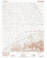
1984 Map of West of Blind Hills
USGS Topo · Published 1984About this map
The Clipper Mountains dominate the southern landscape of this 1984 provisional survey, rising sharply above the Clipper Valley Wash. This arid region within the East Mojave National Scenic Area exhibits the complex drainage patterns of the high desert, with seasonal watercourses like Essex Wash cutting through the terrain. The infrastructure of the era is sparse but telling, featuring a Gravel Pit, a Diversion Dam, and several infrastructure points such as Water Tank Corral that supported local land use before more modern designations took hold.
Find a feature on this map
12 named features on this map. Tap any name to fly to it.
Don’t see what you’re looking for? This feature index may not catch every label — zoom into the map to look around manually.
Map Details
Editions of this 1984 West of Blind Hills Map
This is the sole edition of this map. No revisions or reprints were ever made.
Other maps of this area

1942 · Amboy
USGS Topo · 1:250,000

1943 · Amboy
USGS Topo · 1:250,000

1943 · Danby
USGS Topo · 1:62,500

1954 · Needles
USGS Topo · 1:250,000

1956 · Needles
USGS Topo · 1:250,000

1956 · Colton Well
USGS Topo · 1:62,500

1956 · Cadiz
USGS Topo · 1:62,500

1956 · Danby
USGS Topo · 1:62,500

1956 · Flynn
USGS Topo · 1:62,500

1981 · Needles
USGS Topo · 1:250,000