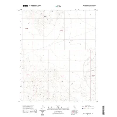
2018 Map of West of Budweiser Wash
USGS Topo · Published 2018About this map
The Bristol Mountains dominate the northern terrain of this remote San Bernardino County landscape, where deep drainage patterns illustrate the arid hydrology of the Mojave Desert. This 2018 survey captures the intersection of several township and range blocks, including t9n r10e and t8n r10e, marking the transition between the rugged volcanic uplands and the alluvial plains. To the southeast, the slopes of the Old Dad Mountains rise above the drainage of Siberia Wash, a prominent dry watercourse that channels seasonal runoff through the desert floor. The map provides a clear record of the vast, undeveloped sections of public and private lands as they existed in the early 21st century, defined by natural topography rather than human settlement.
Find a feature on this map
9 named features on this map. Tap any name to fly to it.
Don’t see what you’re looking for? This feature index may not catch every label — zoom into the map to look around manually.
Map Details
Editions of this 2018 West of Budweiser Wash Map
This is the sole edition of this map. No revisions or reprints were ever made.
Other maps of this area

1942 · Amboy
USGS Topo · 1:250,000

1943 · Amboy
USGS Topo · 1:250,000

1953 · San Bernardino
USGS Topo · 1:250,000

1954 · Needles
USGS Topo · 1:250,000

1955 · Ash Hill
USGS Topo · 1:24,000

1955 · Broadwell Lake
USGS Topo · 1:62,500

1955 · Ludlow
USGS Topo · 1:62,500

1956 · San Bernardino
USGS Topo · 1:250,000

1956 · Needles
USGS Topo · 1:250,000
1956 · Bagdad
USGS Topo · 1:62,500