
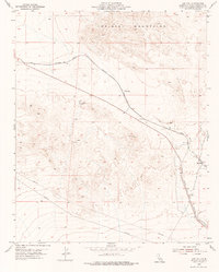
1955 Map of Ash Hill
USGS Topo · Published 1955About this map
The Atchison Topeka and Santa Fe railroad cuts a vital path through this arid portion of San Bernardino County, where the high desert terrain of the Bristol Mountains dominates the northern horizon. In the mid-1950s, the isolated settlement of Ash Hill served as a key point of elevation along the rail line, marked by the VABM 2297 Ash Hill survey monument. Further southeast, the small outpost of Klondike sits near the tracks, illustrating the scattered and precarious nature of habitation in this environment.
Find a feature on this map
10 named features on this map. Tap any name to fly to it.
Don’t see what you’re looking for? This feature index may not catch every label — zoom into the map to look around manually.
Map Details
Editions of this 1955 Ash Hill Map
2 editions found
Other maps of this area

1942 · Amboy
USGS Topo · 1:250,000

1943 · Amboy
USGS Topo · 1:250,000

1953 · San Bernardino
USGS Topo · 1:250,000

1954 · Needles
USGS Topo · 1:250,000

1954 · Bagdad SW
USGS Topo · 1:24,000

1954 · Ludlow SE
USGS Topo · 1:24,000

1955 · Ludlow
USGS Topo · 1:24,000

1955 · Morgans Well
USGS Topo · 1:24,000

1955 · Broadwell Lake
USGS Topo · 1:62,500

1955 · Ludlow
USGS Topo · 1:62,500