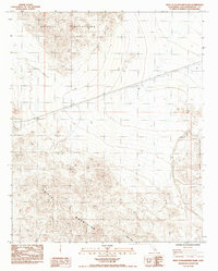
1984 Map of West of Budweiser Wash
USGS Topo · Published 1985About this map
The Bristol Mountains dominate this high-desert landscape in San Bernardino County, where the terrain transitions toward the Old Dad Mountains to the southeast. Compiled from aerial photography taken in the mid-1970s and 1980, this 1984 survey reveals a sparse but industrially active territory. Linear infrastructure, including a prominent pipeline and a trans line, cuts across the arid basins, signaling the region's importance for resource transport. Evidence of local extraction is preserved by a solitary mine located within the mountain slopes. Drainage patterns are clearly defined by the branching network of the Siberia Wash, which serves as a primary hydrological feature in this dry environment. This map is a precise record of the Mojave Desert's utility and mining footprint during the late twentieth century.
Find a feature on this map
6 named features on this map. Tap any name to fly to it.
Don’t see what you’re looking for? This feature index may not catch every label — zoom into the map to look around manually.
Map Details
Editions of this 1984 West of Budweiser Wash Map
This is the sole edition of this map. No revisions or reprints were ever made.
Other maps of this area

1942 · Amboy
USGS Topo · 1:250,000

1943 · Amboy
USGS Topo · 1:250,000

1953 · San Bernardino
USGS Topo · 1:250,000

1954 · Needles
USGS Topo · 1:250,000

1955 · Ash Hill
USGS Topo · 1:24,000

1955 · Broadwell Lake
USGS Topo · 1:62,500

1955 · Ludlow
USGS Topo · 1:62,500

1956 · San Bernardino
USGS Topo · 1:250,000

1956 · Needles
USGS Topo · 1:250,000
1956 · Bagdad
USGS Topo · 1:62,500