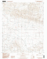
1996 Map of West of Drinkwater Lake
USGS Topo · Published 1998About this map
Fort Irwin Military Reservation dominates this Mojave Desert landscape as it appeared in the mid-1990s. The survey provides a high-resolution view of the specialized terrain within the installation, focusing on the arid stretches located just west of Drinkwater Lake. The northern half of the map is defined by the steep elevation changes and intricate drainage patterns of the Granite Mountains, which reach heights of several thousand feet before giving way to the lower-lying alluvial fans and desert flats to the south. This area serves as a critical zone for military maneuvers, and the cartography captures the complex network of unimproved roads and survey markers essential for navigation in such a remote environment.
Find a feature on this map
2 named features on this map. Tap any name to fly to it.
Don’t see what you’re looking for? This feature index may not catch every label — zoom into the map to look around manually.
Map Details
Editions of this 1996 West of Drinkwater Lake Map
This is the sole edition of this map. No revisions or reprints were ever made.
Other maps of this area

1933 · Avawatz Mountains
USGS Topo · 1:250,000

1947 · Trona
USGS Topo · 1:250,000

1948 · Trona
USGS Topo · 1:250,000

1948 · Quail Mountains
USGS Topo · 1:62,500

1948 · Leach Lake
USGS Topo · 1:62,500

1948 · Goldstone Lake
USGS Topo · 1:62,500

1948 · Tiefort Mountains
USGS Topo · 1:62,500

1951 · Goldstone Lake
USGS Topo · 1:62,500

1951 · Tiefort Mountains
USGS Topo · 1:62,500

1951 · Quail Mountains
USGS Topo · 1:62,500