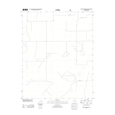
2012 Map of West of Kerrick
USGS Topo · Published 2012About this map
The northernmost reaches of the Texas Panhandle in Dallam County reveal a high plains landscape defined by its grid of rural access routes and scattered livestock tanks. During this early 21st-century period, the area reflects the enduring geometry of large-scale ranching and agriculture, where long stretches of road like Sandy Trail Rd and Hampton Rd provide the primary framework for movement. The terrain is marked by ephemeral water features and depressional basins, characteristic of the region’s hydrology. These small basins and the local road network, including family-named ways like Whittenburg Ln and Hank Ln, offer a clear picture of land ownership and management in this high-altitude corner of Texas. The absence of dense town sites highlights the importance of specific named corridors like Doug Ln and K O Ln in navigating the vast open range.
Find a feature on this map
6 named features on this map. Tap any name to fly to it.
Don’t see what you’re looking for? This feature index may not catch every label — zoom into the map to look around manually.
Map Details
Editions of this 2012 West of Kerrick Map
This is the sole edition of this map. No revisions or reprints were ever made.
Other maps of this area

1954 · Dalhart
USGS Topo · 1:250,000

1958 · Dalhart
USGS Topo · 1:250,000

1962 · Dalhart
USGS Topo · 1:250,000

1964 · Brickel
USGS Topo · 1:24,000

1964 · Kerrick
USGS Topo · 1:24,000

1964 · Stratford 2 SE
USGS Topo · 1:24,000

1964 · Stratford 2 NE
USGS Topo · 1:24,000

1971 · Griggs SW
USGS Topo · 1:24,000

1971 · Conrad SW
USGS Topo · 1:24,000
1971 · Conrad
USGS Topo · 1:24,000