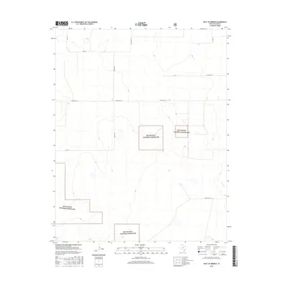
2016 Map of West of Kerrick
USGS Topo · Published 2016About this map
The Rita Blanca National Grassland dominates this high plains landscape in the far northwestern corner of the Texas Panhandle. Fragmented parcels of protected federal land are interspersed with private holdings, illustrating the complex land-use patterns of Dallam County. This 2016 survey details a grid of rural roads named for local families and landmarks, such as Whittenburg Ln, Minnie Mack Ln, and Schoonover Ln. The terrain is characterized by subtle elevation changes and seasonal wetlands, typical of the shortgrass prairie. The presence of routes like Sandy Trail Rd and Hermit Rd highlights the sparse, remote nature of the region, where the economy remains tied to the vast grasslands and agriculture.
Find a feature on this map
11 named features on this map. Tap any name to fly to it.
Don’t see what you’re looking for? This feature index may not catch every label — zoom into the map to look around manually.
Map Details
Editions of this 2016 West of Kerrick Map
This is the sole edition of this map. No revisions or reprints were ever made.
Other maps of this area

1954 · Dalhart
USGS Topo · 1:250,000

1958 · Dalhart
USGS Topo · 1:250,000

1962 · Dalhart
USGS Topo · 1:250,000

1964 · Brickel
USGS Topo · 1:24,000

1964 · Kerrick
USGS Topo · 1:24,000

1964 · Stratford 2 SE
USGS Topo · 1:24,000

1964 · Stratford 2 NE
USGS Topo · 1:24,000

1971 · Griggs SW
USGS Topo · 1:24,000

1971 · Conrad SW
USGS Topo · 1:24,000
1971 · Conrad
USGS Topo · 1:24,000