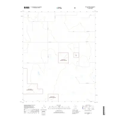
2019 Map of West of Kerrick
USGS Topo · Published 2019About this map
Rita Blanca National Grassland segments dominate this portion of the Texas Panhandle in Dallam County. This landscape of the Great Plains reflects the legacy of the Dust Bowl era, where these protected lands were established to restore the native shortgrass prairie. The mapping of Whittenburg Ln and Minnie Mack Ln suggests a sparse network of ranch roads and section-line tracks typical of the region’s expansive cattle-ranching operations. Smaller plots, such as the one labeled Rb Ng, are interspersed with private holdings, illustrating the patchwork nature of land management in the High Plains. Drainage patterns and subtle contours provide a framework for the rural infrastructure, including Schoonover Ln and Sandy Trail Rd, which connect isolated homesteads and grazing tracts across this open terrain.
Find a feature on this map
12 named features on this map. Tap any name to fly to it.
Don’t see what you’re looking for? This feature index may not catch every label — zoom into the map to look around manually.
Map Details
Editions of this 2019 West of Kerrick Map
This is the sole edition of this map. No revisions or reprints were ever made.
Other maps of this area

1954 · Dalhart
USGS Topo · 1:250,000

1958 · Dalhart
USGS Topo · 1:250,000

1962 · Dalhart
USGS Topo · 1:250,000

1964 · Brickel
USGS Topo · 1:24,000

1964 · Kerrick
USGS Topo · 1:24,000

1964 · Stratford 2 SE
USGS Topo · 1:24,000

1964 · Stratford 2 NE
USGS Topo · 1:24,000

1971 · Griggs SW
USGS Topo · 1:24,000

1971 · Conrad SW
USGS Topo · 1:24,000
1971 · Conrad
USGS Topo · 1:24,000