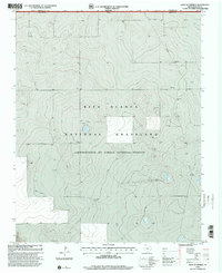
1998 Map of West of Kerrick
USGS Topo · Published 2001About this map
Rita Blanca National Grassland dominates this corner of the Texas Panhandle, where the high plains meet the Oklahoma border. This late-twentieth-century revision reveals a landscape primarily defined by energy infrastructure and land management. The presence of several Gas Wells, a prominent north-south Pipeline, and a Substation illustrates the region's mid-to-late century industrial development within Dallam County. While the topography is characterized by subtle elevation changes and depressions typical of the Llano Estacado, the human footprint is seen in the systematic placement of industrial sites and the clear demarcation of the state line between Oklahoma and Texas. The map also identifies scattered water sources such as a Well, essential for maintaining life and industry in this semi-arid environment.
Find a feature on this map
7 named features on this map. Tap any name to fly to it.
Don’t see what you’re looking for? This feature index may not catch every label — zoom into the map to look around manually.
Map Details
Editions of this 1998 West of Kerrick Map
This is the sole edition of this map. No revisions or reprints were ever made.
Other maps of this area

1954 · Dalhart
USGS Topo · 1:250,000

1958 · Dalhart
USGS Topo · 1:250,000

1962 · Dalhart
USGS Topo · 1:250,000

1964 · Brickel
USGS Topo · 1:24,000

1964 · Kerrick
USGS Topo · 1:24,000

1964 · Stratford 2 SE
USGS Topo · 1:24,000

1964 · Stratford 2 NE
USGS Topo · 1:24,000

1971 · Griggs SW
USGS Topo · 1:24,000

1971 · Conrad SW
USGS Topo · 1:24,000
1971 · Conrad
USGS Topo · 1:24,000