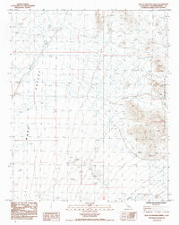
1985 Map of West of Mohawk Spring
USGS Topo · Published 1985About this map
Ward Valley dominates this 1980s landscape, illustrating the arid expanse of the eastern Mojave Desert. Along the eastern edge of the quadrangle, the slopes of the Turtle Mountains rise sharply, marked by high-elevation contours and isolated Prospects that hint at localized mineral exploration. Drainage patterns are defined by the wide path of Homer Wash, which cuts through the valley floor, collecting runoff from the surrounding uplands during rare desert rain events.
Find a feature on this map
8 named features on this map. Tap any name to fly to it.
Don’t see what you’re looking for? This feature index may not catch every label — zoom into the map to look around manually.
Map Details
Editions of this 1985 West of Mohawk Spring Map
This is the sole edition of this map. No revisions or reprints were ever made.
Other maps of this area

1942 · Amboy
USGS Topo · 1:250,000

1943 · Center Hills
USGS Topo · 1:62,500

1943 · Amboy
USGS Topo · 1:250,000

1943 · Essex
USGS Topo · 1:62,500

1943 · Turtle Mts.
USGS Topo · 1:62,500

1954 · Needles
USGS Topo · 1:250,000

1954 · Turtle Mountains
USGS Topo · 1:62,500

1956 · Needles
USGS Topo · 1:250,000

1956 · Milligan
USGS Topo · 1:62,500

1956 · Essex
USGS Topo · 1:62,500