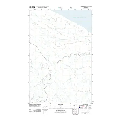
2011 Map of West of Pysht
USGS Topo · Published 2011About this map
The Strait of Juan de Fuca shoreline meets a landscape defined by complex drainage basins on the Olympic Peninsula. The Pysht River dominates the central terrain, fed by various tributaries including the South Fork Pysht River, Needham Creek, and Salmonberry Creek. This 2011 survey documents a primarily forested area where major landforms like Burnt Mountain rise between the winding waterways. The map illustrates the 21st-century road network through the region, featuring State Routes 112 and 113 which provide access to the coastal and inland timberlands. Smaller waterways such as Pearson Creek and Last Creek drain northern slopes toward the strait, while Middle Creek and Green Creek mark the diverse hydrological patterns of this coastal washington territory.
Find a feature on this map
15 named features on this map. Tap any name to fly to it.
Don’t see what you’re looking for? This feature index may not catch every label — zoom into the map to look around manually.
Map Details
Editions of this 2011 West of Pysht Map
This is the sole edition of this map. No revisions or reprints were ever made.
Other maps of this area

1922 · Pysht
USGS Topo · 1:62,500

1935 · Clallam
USGS Topo · 1:62,500

1935 · Lake Pleasant
USGS Topo · 1:62,500

1942 · Pysht
USGS Topo · 1:62,500

1942 · Clallam
USGS Topo · 1:62,500

1942 · Lake Pleasant
USGS Topo · 1:62,500

1953 · Cape Flattery
USGS Topo · 1:250,000

1957 · Lake Pleasant
USGS Topo · 1:62,500
1957 · Pysht
USGS Topo · 1:62,500
1957 · Clallam Bay
USGS Topo · 1:62,500