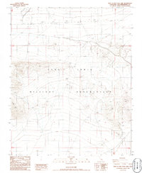
1986 Map of West of Red Pass Lake
USGS Topo · Published 1986About this map
The Fort Irwin Military Reservation dominates this 1980s landscape, reflecting the heavy military presence in the High Desert of San Bernardino County. The terrain is defined by the sharp rise of the Tiefort Mts, where steep contour lines reveal a complex network of arid ridges and dry washes. Unlike typical civilian maps of the era, the land here is largely devoid of domestic settlements, schools, or churches, focusing instead on the topographical challenges of a training environment. Strategic water management and land modification are evident in the series of Levee structures positioned across the northern flats, likely built to manage seasonal runoff and protect maneuver areas from flash flooding. This map provides a clear view of the Mojave's natural desert geometry before more modern tactical developments on the base.
Find a feature on this map
8 named features on this map. Tap any name to fly to it.
Don’t see what you’re looking for? This feature index may not catch every label — zoom into the map to look around manually.
Map Details
Editions of this 1986 West of Red Pass Lake Map
This is the sole edition of this map. No revisions or reprints were ever made.
Other maps of this area

1933 · Avawatz Mountains
USGS Topo · 1:250,000

1947 · Trona
USGS Topo · 1:250,000

1948 · Red Pass Lake
USGS Topo · 1:62,500

1948 · Trona
USGS Topo · 1:250,000

1948 · Alvord Mountain
USGS Topo · 1:62,500

1948 · Cave Mountain
USGS Topo · 1:62,500

1948 · Tiefort Mountains
USGS Topo · 1:62,500

1951 · Tiefort Mountains
USGS Topo · 1:62,500

1951 · Cave Mountain
USGS Topo · 1:62,500

1951 · Alvord Mountain
USGS Topo · 1:62,500