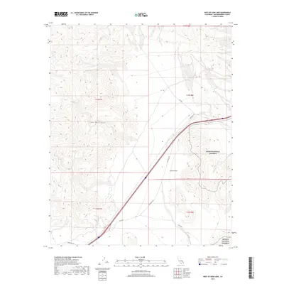
2018 Map of West of Soda Lake
USGS Topo · Published 2018About this map
Soda Mountains dominate the western portion of this 2018 survey, rising above the arid expanse of the Mojave Desert. The map captures a critical transition where the mountain terrain meets the low-lying basins, specifically within the western reaches of the Mojave National Preserve. Transportation through this desert landscape is defined by long-established routes, including the iconic Zzyzx Rd and Arrowhead Trl, which navigate the elevation changes between the peaks and the lake beds. The survey also delineates the complex township and range boundaries such as t13n r7e and t12n r8e, illustrating the systematic division of this remote San Bernardino County terrain for land management and public land use.
Find a feature on this map
11 named features on this map. Tap any name to fly to it.
Don’t see what you’re looking for? This feature index may not catch every label — zoom into the map to look around manually.
Map Details
Editions of this 2018 West of Soda Lake Map
This is the sole edition of this map. No revisions or reprints were ever made.
Other maps of this area

1933 · Avawatz Mountains
USGS Topo · 1:250,000

1947 · Trona
USGS Topo · 1:250,000

1948 · Red Pass Lake
USGS Topo · 1:62,500

1948 · Trona
USGS Topo · 1:250,000

1948 · Cave Mountain
USGS Topo · 1:62,500

1951 · Cave Mountain
USGS Topo · 1:62,500

1951 · Red Pass Lake
USGS Topo · 1:62,500

1953 · Trona
USGS Topo · 1:250,000
1956 · Soda Lake
USGS Topo · 1:62,500

1956 · Baker
USGS Topo · 1:62,500