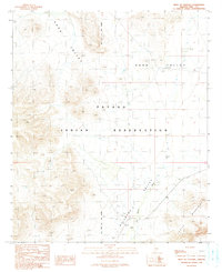
1990 Map of West of Ventana
USGS Topo · Published 1991About this map
The Papago Indian Reservation encompasses this high desert landscape, defined by broad alluvial basins and isolated peaks. This 1990 provisional survey documents a transition in mapping history, combining original 1961 aerial photography with limited revisions from the mid-1980s. The terrain is characterized by the expansive Kaka Valley and the Quijotoa Valley, where seasonal drainage patterns like the San Simon Wash provide the primary geographic structure. To the southeast, the Castle Mountains rise sharply, offering a stark contrast to the surrounding valley floors. The presence of the Gila and Salt River Meridian serves as a critical surveying benchmark for the region. The map reflects a landscape with minimal modern infrastructure, highlighting unimproved roads and trails that connect remote desert reaches before the turn of the 21st century.
Find a feature on this map
7 named features on this map. Tap any name to fly to it.
Don’t see what you’re looking for? This feature index may not catch every label — zoom into the map to look around manually.
Map Details
Editions of this 1990 West of Ventana Map
This is the sole edition of this map. No revisions or reprints were ever made.
Other maps of this area

1941 · Vekol Mountains
USGS Topo · 1:62,500

1942 · Vekol Mountains
USGS Topo · 1:62,500

1953 · Ajo
USGS Topo · 1:250,000

1957 · Ajo
USGS Topo · 1:250,000

1958 · Ajo
USGS Topo · 1:250,000

1958 · Kaka
USGS Topo · 1:62,500

1962 · Ajo
USGS Topo · 1:250,000

1963 · Ajo
USGS Topo · 1:250,000

1963 · Gu Achi
USGS Topo · 1:62,500

1963 · Cimarron Peak
USGS Topo · 1:62,500