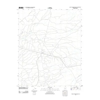
2011 Map of West of Window Rock
USGS Topo · Published 2011About this map
Kinlichee Creek and Wide Ruin Wash define the drainage patterns of this high-elevation landscape within the Fort Defiance Agency region. The map illustrates a transition in land use where the Summit Campground serves as a central recreational point near the junction of several arterial routes. The road network is particularly distinct, featuring a series of numbered paths such as Indian Rte 9500 and Indian Rte 2010, which provide access through the open terrain.
Find a feature on this map
12 named features on this map. Tap any name to fly to it.
Don’t see what you’re looking for? This feature index may not catch every label — zoom into the map to look around manually.
Map Details
Editions of this 2011 West of Window Rock Map
This is the sole edition of this map. No revisions or reprints were ever made.
Other maps of this area

1886 · Fort Defiance
USGS Topo · 1:250,000

1892 · Fort Defiance
USGS Topo · 1:250,000

1954 · Gallup
USGS Topo · 1:250,000

1955 · Zith-Tusayan Butte 2 SE
USGS Topo · 1:24,000

1955 · Zith-Tusayan Butte 4 NW
USGS Topo · 1:24,000

1955 · Zith-Tusayan Butte 3 NE
USGS Topo · 1:24,000

1955 · Zith-Tusayan Butte 4 NE
USGS Topo · 1:24,000

1955 · Zith-Tusayan Butte 1 SE
USGS Topo · 1:24,000
1955 · Zith-Tusayan Butte 1 SW
USGS Topo · 1:24,000
1955 · Nazlini
USGS Topo · 1:62,500