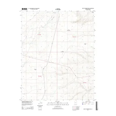
2014 Map of West of Window Rock
USGS Topo · Published 2014About this map
The Defiance Plateau rises across this section of the Navajo Nation, where the terrain is carved by complex drainages and deep canyons. Bear Canyon and Natural Bridge Canyon dominate the northern landscape, feeding into the watershed of Kinlichee Cr. To the south, the expansive Wide Ruin Valley opens up, drained by the Wide Ruin Wash. The map documents a sparse but vital network of Bureau of Indian Affairs routes, including Bia-201 and Bia-1381, which connect remote homesteads across the high desert. In the southeast, the landscape transitions toward Cienega Cr and the branching paths of Aspen Canyon and Juniper Bark Canyon, illustrating the high-elevation forest and canyon environment west of the tribal headquarters.
Find a feature on this map
24 named features on this map. Tap any name to fly to it.
Don’t see what you’re looking for? This feature index may not catch every label — zoom into the map to look around manually.
Map Details
Editions of this 2014 West of Window Rock Map
This is the sole edition of this map. No revisions or reprints were ever made.
Other maps of this area

1886 · Fort Defiance
USGS Topo · 1:250,000

1892 · Fort Defiance
USGS Topo · 1:250,000

1954 · Gallup
USGS Topo · 1:250,000

1955 · Zith-Tusayan Butte 2 SE
USGS Topo · 1:24,000

1955 · Zith-Tusayan Butte 4 NW
USGS Topo · 1:24,000

1955 · Zith-Tusayan Butte 3 NE
USGS Topo · 1:24,000

1955 · Zith-Tusayan Butte 4 NE
USGS Topo · 1:24,000

1955 · Zith-Tusayan Butte 1 SE
USGS Topo · 1:24,000
1955 · Zith-Tusayan Butte 1 SW
USGS Topo · 1:24,000
1955 · Nazlini
USGS Topo · 1:62,500