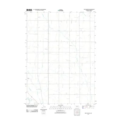
2011 Map of West Point NW
USGS Topo · Published 2011About this map
Cuming Creek and its many meandering tributaries define this portion of Cuming County, where the agricultural landscape is precisely divided by a geometric grid of rural roads. In the southwestern corner, the Elkhorn River cuts a wide path through the terrain, joined by the waters of Plum Creek and Felix Creek. This 2011 survey reveals a sparsely populated region dedicated to large-scale farming, with local history anchored by the Dewitt Cemetery located along 15th Road. The systematic naming of thoroughfares, such as L Rd and M Rd, reflects the organized land management typical of the Nebraska plains, while Little Logan Creek touches the northern reaches of the quadrangle.
Find a feature on this map
15 named features on this map. Tap any name to fly to it.
Don’t see what you’re looking for? This feature index may not catch every label — zoom into the map to look around manually.
Map Details
Editions of this 2011 West Point NW Map
This is the sole edition of this map. No revisions or reprints were ever made.
Other maps of this area

1955 · Sioux City
USGS Topo · 1:250,000

1955 · Fremont
USGS Topo · 1:250,000

1957 · Fremont
USGS Topo · 1:250,000

1958 · Sioux City
USGS Topo · 1:250,000

1958 · Fremont
USGS Topo · 1:250,000

1959 · Sioux City
USGS Topo · 1:250,000

1966 · West Point NW
USGS Topo · 1:24,000

1966 · West Point SE
USGS Topo · 1:24,000

1966 · Monterey
USGS Topo · 1:24,000
1966 · Beemer
USGS Topo · 1:24,000