
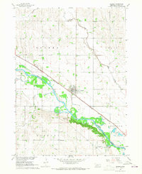
1966 Map of West Point NW
USGS Topo · Published 1967About this map
St. Charles sits at the southwestern edge of this Cuming County landscape, positioned where the Chicago and North Western railroad corridor meets the broad valley of the Elkhorn River. This mid-century survey illustrates a deeply rural agricultural pattern across the townships of Logan, Neligh, Sherman, and Garfield. The social fabric of the era is evident in the distribution of one-room schoolhouses and community hubs, including School No 28, School No 22, and the Zion Sch, along with a local Townhall.
Find a feature on this map
18 named features on this map. Tap any name to fly to it.
Don’t see what you’re looking for? This feature index may not catch every label — zoom into the map to look around manually.
Map Details
Editions of this 1966 West Point NW Map
This is the sole edition of this map. No revisions or reprints were ever made.
Other maps of this area

1955 · Sioux City
USGS Topo · 1:250,000

1955 · Fremont
USGS Topo · 1:250,000

1957 · Fremont
USGS Topo · 1:250,000

1958 · Sioux City
USGS Topo · 1:250,000

1958 · Fremont
USGS Topo · 1:250,000

1959 · Sioux City
USGS Topo · 1:250,000

1966 · West Point SE
USGS Topo · 1:24,000

1966 · Monterey
USGS Topo · 1:24,000
1966 · Beemer
USGS Topo · 1:24,000

1966 · West Point NE
USGS Topo · 1:24,000