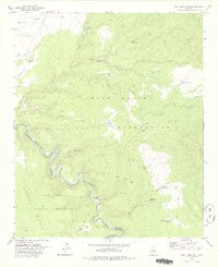
1978 Map of West Poker Mtn.
USGS Topo · Published 1978About this map
The Black River carves a deep, meandering path through this high-country landscape, serving as the critical Reservation Boundary between the Fort Apache Indian Reservation and the San Carlos Indian Reservation. This map reveals a complex system of water management essential for ranching in the arid high desert, marked by numerous livestock tanks such as Carlos Moody Tank, Heifer Tank, and I D Tank No 2. The terrain is defined by dramatic elevation changes from the Natanes Plateau and West Poker Mtn down into steep drainages like Mule Corral Canyon and Poker Canyon. Human presence is primarily represented by a network of unimproved routes, including the Burnt Corral Trail and various jeep trails, which navigate around landmarks like the deep basin of Hells Hole.
Find a feature on this map
34 named features on this map. Tap any name to fly to it.
Don’t see what you’re looking for? This feature index may not catch every label — zoom into the map to look around manually.
Map Details
Editions of this 1978 West Poker Mtn. Map
This is the sole edition of this map. No revisions or reprints were ever made.
Other maps of this area

1954 · Clifton
USGS Topo · 1:250,000

1957 · Clifton
USGS Topo · 1:250,000

1958 · Clifton
USGS Topo · 1:250,000

1962 · Clifton
USGS Topo · 1:250,000
1967 · Sawbuck Mtn.
USGS Topo · 1:24,000
1967 · Maverick SW
USGS Topo · 1:24,000
1967 · West Poker Mtn.
USGS Topo · 1:24,000

1967 · Odart Mtn
USGS Topo · 1:24,000
1967 · Elwood Canyon
USGS Topo · 1:24,000
1967 · Corn Creek
USGS Topo · 1:24,000