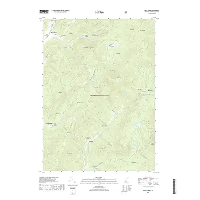
2018 Map of West Rupert
USGS Topo · Published 2018About this map
Green Mountain National Forest dominates this section of Bennington County, where the steep ridgelines of the Taconic and Green Mountains create a landscape of narrow valleys and isolated hollows. The settlement pattern is defined by these corridors, with West Rupert situated along Mill Brook and Sandgate nestled between Swearing Hill and Minister Hill. This terrain fostered small, self-sufficient communities in the 19th and 20th centuries, many of which are identified here by family-named hollows like Youlin Hollow, Moffitt Hollow, and Corbett Hollow. Numerous small burial grounds, including the West Rupert Cem and the remote Beartown Cem, provide significant markers for genealogical research in this rural borderland. The area's physical geography is highlighted by prominent peaks such as Equinox Mtn and unique landforms like The Ox Bow and The Notch, illustrating the difficult passage between the valleys of White Cr and the Green River.
Find a feature on this map
93 named features on this map. Tap any name to fly to it.
Don’t see what you’re looking for? This feature index may not catch every label — zoom into the map to look around manually.
Map Details
Editions of this 2018 West Rupert Map
This is the sole edition of this map. No revisions or reprints were ever made.
Other maps of this area

1893 · Fort Ann
USGS Topo · 1:62,500

1894 · Pawlet
USGS Topo · 1:62,500

1894 · Equinox
USGS Topo · 1:62,500

1895 · Cambridge
USGS Topo · 1:62,500

1895 · Fort Ann
USGS Topo · 1:62,500

1896 · Equinox
USGS Topo · 1:62,500

1897 · Pawlet
USGS Topo · 1:62,500

1898 · Cambridge
USGS Topo · 1:62,500

1898 · Fort Ann
USGS Topo · 1:62,500

1900 · Equinox
USGS Topo · 1:62,500