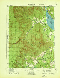
1943 Map of West Shokan
USGS Topo · Published 1943About this map
Ashokan Reservoir dominates the eastern edge of this 1943 survey, its deep waters abutting the high peaks of the Catskills during the early years of the war. This map captures the intricate relationship between the watershed and the surrounding mountain hamlets like West Shokan and Samsonville. The western reaches of the quadrangle are defined by extreme verticality, featuring notable summits such as Cornell Mountain and Mombaccus Mt, while the valley floors are dotted with isolated homesteads and local institutions.
Find a feature on this map
61 named features on this map. Tap any name to fly to it.
Don’t see what you’re looking for? This feature index may not catch every label — zoom into the map to look around manually.
Map Details
Editions of this 1943 West Shokan Map
This is the sole edition of this map. No revisions or reprints were ever made.
Other maps of this area

1892 · Kaaterskill
USGS Topo · 1:62,500

1893 · Kaaterskill
USGS Topo · 1:62,500

1894 · Kaaterskill
USGS Topo · 1:62,500

1899 · Kaaterskill
USGS Topo · 1:62,500

1900 · Phoenicia
USGS Topo · 1:62,500

1901 · Rosendale
USGS Topo · 1:62,500

1903 · Rosendale
USGS Topo · 1:62,500

1903 · Phoenicia
USGS Topo · 1:62,500

1903 · Kaaterskill
USGS Topo · 1:62,500

1903 · Slide Mountain
USGS Topo · 1:62,500