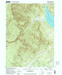
1997 Map of West Shokan
USGS Topo · Published 2001About this map
The Ashokan Reservoir dominates the northeastern landscape of this map, reflecting the early 20th-century transformation of the Catskills into a critical water supply for New York City. Surrounding the reservoir, the vast Catskill State Park and State Forest Preserve protect a series of high peaks, including Friday Mtn and Mombaccus Mtn. The terrain is deeply incised by waters such as the Bush Kill and Rondout Creek, which historically dictated the placement of small hamlets and timber-based industries.
Find a feature on this map
68 named features on this map. Tap any name to fly to it.
Don’t see what you’re looking for? This feature index may not catch every label — zoom into the map to look around manually.
Map Details
Editions of this 1997 West Shokan Map
This is the sole edition of this map. No revisions or reprints were ever made.
Other maps of this area

1892 · Kaaterskill
USGS Topo · 1:62,500

1893 · Kaaterskill
USGS Topo · 1:62,500

1894 · Kaaterskill
USGS Topo · 1:62,500

1899 · Kaaterskill
USGS Topo · 1:62,500

1900 · Phoenicia
USGS Topo · 1:62,500

1901 · Rosendale
USGS Topo · 1:62,500

1903 · Rosendale
USGS Topo · 1:62,500

1903 · Phoenicia
USGS Topo · 1:62,500

1903 · Kaaterskill
USGS Topo · 1:62,500

1903 · Slide Mountain
USGS Topo · 1:62,500