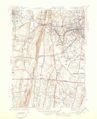
1945 Map of West Springfield
USGS Topo · Published 1945About this map
The Westfield River defines the northern industrial and residential corridor of this mid-century landscape, where the Boston and Albany RR passes through Westfield and West Springfield. This map captures a distinct era of institutional land use, shown through the large grounds of the Westfield State Sanatorium and the Hampden County Training Sch. These facilities, alongside various water infrastructure like the Waterworks and Covered Reservoir, illustrate the expansion of public services during the early 1940s.
Find a feature on this map
91 named features on this map. Tap any name to fly to it.
Don’t see what you’re looking for? This feature index may not catch every label — zoom into the map to look around manually.
Map Details
Editions of this 1945 West Springfield Map
2 editions found
Other maps of this area

1886 · Springfield
USGS Topo · 1:62,500

1887 · Granville
USGS Topo · 1:62,500

1889 · Springfield
USGS Topo · 1:62,500

1889 · Granville
USGS Topo · 1:62,500

1892 · Hartford
USGS Topo · 1:62,500

1892 · Granby
USGS Topo · 1:62,500

1893 · Springfield
USGS Topo · 1:62,500

1893 · Granville
USGS Topo · 1:62,500

1895 · Springfield
USGS Topo · 1:62,500

1895 · Granville
USGS Topo · 1:62,500