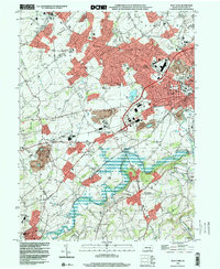
1998 Map of West York
USGS Topo · Published 2000About this map
The suburban expansion of West York and York dominates the landscape of this late-twentieth-century survey, revealing a network of residential developments and commercial corridors. The historic Lincoln Highway serves as a primary artery through West Manchester, passing the York Airport and a nostalgic Drive-in Theater near Thomasville. This era captures the transition of rural townships into modern communities while maintaining numerous landmarks of local heritage, including the St Pauls Union Ch and several small rural schools like Township Sch No 1 and Heindel Sch.
Find a feature on this map
73 named features on this map. Tap any name to fly to it.
Don’t see what you’re looking for? This feature index may not catch every label — zoom into the map to look around manually.
Map Details
Editions of this 1998 West York Map
This is the sole edition of this map. No revisions or reprints were ever made.
Other maps of this area

1906 · New Cumberland
USGS Topo · 1:62,500

1908 · Middletown
USGS Topo · 1:62,500

1908 · York
USGS Topo · 1:62,500

1910 · York
USGS Topo · 1:62,500

1920 · Hanover
USGS Topo · 1:62,500

1922 · Hanover
USGS Topo · 1:62,500

1943 · New Cumberland
USGS Topo · 1:62,500

1943 · Middletown
USGS Topo · 1:62,500

1948 · Baltimore
USGS Topo · 1:250,000

1950 · Harrisburg
USGS Topo · 1:250,000