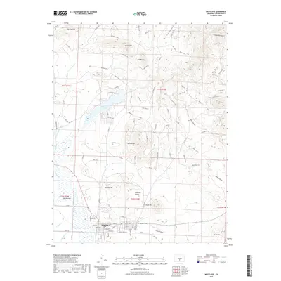
2019 Map of Westcliffe
USGS Topo · Published 2019About this map
Silver Cliff and Westcliffe sit as the primary hubs of the Wet Mountain Valley on this recent survey. The adjacency of these two towns highlights the local history of the silver mining era, with the Silver Cliff Plateau and Rosita Hills framing the valley floor. Water management is a central theme of the landscape, evident in the Lohstroh Highline Ditch and the Deweese-Dye Reservoir, which captures flow from Grape Creek. The map provides detailed placement of civil landmarks like the Custer County Courthouse, while surrounding peaks including Mitchell Mtn and Dora Mtn define the area's high-altitude character. A dense network of residential roads like Bella Vista Trce and Silver Circle Dr shows the contemporary footprint of these communities against the backdrop of Bull Domingo Hills and Ben West Hill.
Find a feature on this map
97 named features on this map. Tap any name to fly to it.
Don’t see what you’re looking for? This feature index may not catch every label — zoom into the map to look around manually.
Map Details
Editions of this 2019 Westcliffe Map
This is the sole edition of this map. No revisions or reprints were ever made.
Other maps of this area

1889 · Canon City
USGS Topo · 1:125,000

1892 · Canon City
USGS Topo · 1:125,000

1954 · Mount Tyndall
USGS Topo · 1:24,000

1954 · Rosita
USGS Topo · 1:24,000

1954 · Pueblo
USGS Topo · 1:250,000

1955 · Westcliffe
USGS Topo · 1:24,000

1957 · Pueblo
USGS Topo · 1:250,000

1957 · Aldrich Gulch
USGS Topo · 1:24,000

1958 · Pueblo
USGS Topo · 1:250,000

1958 · Beckwith Mountain
USGS Topo · 1:24,000