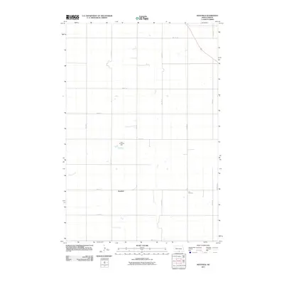
2011 Map of Westfield
USGS Topo · Published 2011About this map
Westfield serves as a central point in this early 21st-century prairie landscape, where the grid of rural section lines is meticulously defined by routes like 10th Ave SE and 96th St SE. The terrain is shaped by subtle water features, including the winding course of Decker Creek and the localized catchment at Karl Vanderval Dam. This map reveals the dispersed nature of settlement in southern Emmons County, where community landmarks like the Hull Cemetery are situated at significant distances from the primary residential clusters. The spatial arrangement of these features illustrates a landscape dedicated to agriculture, where distance and the section-line road network dictate the flow of local life and commerce.
Find a feature on this map
18 named features on this map. Tap any name to fly to it.
Don’t see what you’re looking for? This feature index may not catch every label — zoom into the map to look around manually.
Map Details
Editions of this 2011 Westfield Map
This is the sole edition of this map. No revisions or reprints were ever made.
Other maps of this area
1953 · McIntosh
USGS Topo · 1:250,000
1954 · Bismarck
USGS Topo · 1:250,000
1958 · Bismarck
USGS Topo · 1:250,000
1958 · McIntosh
USGS Topo · 1:250,000
1965 · Herreid NW
USGS Topo · 1:24,000
1965 · Herreid NE
USGS Topo · 1:24,000
1965 · Pollock
USGS Topo · 1:24,000
1971 · Grassna
USGS Topo · 1:24,000
1971 · Grassna NE
USGS Topo · 1:24,000
1971 · Strasburg
USGS Topo · 1:24,000