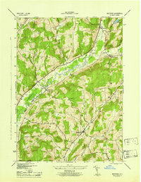
1945 Map of Westford
USGS Topo · Published 1945About this map
Cherry Valley Creek meanders through a central corridor of this Otsego County landscape, anchoring a valley of agricultural settlements and family-named terrain. The map captures the distinct rural organization of Middlefield, Roseboom, and Westford just as the mid-century era took hold. Several district schoolhouses, such as School No 10 and School No 7, remain clearly marked, providing critical data points for genealogists tracing ancestral homesteads in the uplands surrounding Hubbell Hollow.
Find a feature on this map
28 named features on this map. Tap any name to fly to it.
Don’t see what you’re looking for? This feature index may not catch every label — zoom into the map to look around manually.
Map Details
Editions of this 1945 Westford Map
This is the sole edition of this map. No revisions or reprints were ever made.
Other maps of this area

1898 · Canajoharie
USGS Topo · 1:62,500

1900 · Canajoharie
USGS Topo · 1:62,500

1902 · Canajoharie
USGS Topo · 1:62,500

1903 · Richfield Springs
USGS Topo · 1:62,500

1904 · Richmondville
USGS Topo · 1:62,500

1907 · Cooperstown
USGS Topo · 1:62,500

1909 · Cooperstown
USGS Topo · 1:62,500

1943 · Milford
USGS Topo · 1:24,000

1943 · South Valley
USGS Topo · 1:24,000

1943 · Richfield Springs
USGS Topo · 1:24,000