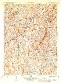
1945 Map of Westford
USGS Topo · Published 1945About this map
Westford and Union anchor this 1945 survey of the highlands where the Mount Hope River and Fenton River originate. The landscape is a network of small ponds and early educational outposts, featuring the Red Sch, Rock Meadow Sch, and Moose Meadow Sch tucked between prominent elevations like Lead Mine Hill and Stickney Hill. The distribution of burial sites, including the Swamp Burying Ground and Moose Meadow Cem, suggests a long-established rural population settled amidst the dense terrain of the Natchaug State Forest. The map also captures the early presence of the Wilbur Cross Highway as it cuts through the northern section, marking a modern transport artery through a region still defined by isolated farmsteads and small settlements like Tinkerville.
Find a feature on this map
75 named features on this map. Tap any name to fly to it.
Don’t see what you’re looking for? This feature index may not catch every label — zoom into the map to look around manually.
Map Details
Editions of this 1945 Westford Map
2 editions found
Other maps of this area

1887 · Brookfield
USGS Topo · 1:62,500

1887 · Palmer
USGS Topo · 1:62,500

1889 · Palmer
USGS Topo · 1:62,500

1890 · Brookfield
USGS Topo · 1:62,500

1892 · Woodstock
USGS Topo · 1:62,500

1892 · Tolland
USGS Topo · 1:62,500

1893 · Palmer
USGS Topo · 1:62,500

1893 · Brookfield
USGS Topo · 1:62,500

1908 · Ware
USGS Topo · 1:125,000

1915 · Brookfield
USGS Topo · 1:62,500