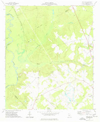
1974 Map of Westlake
USGS Topo · Published 1977About this map
The Ocmulgee River defines the western edge of this central Georgia landscape, winding through a complex of swamps and lowlands where the boundaries of Twiggs, Houston, Bleckley, and Pulaski counties meet. In the mid-1970s, the Southern railroad corridor provided a primary transit link between the small settlements of Westlake and Coley, cutting across the drainage systems of Shellstone Creek and South Shellstone Creek.
Find a feature on this map
39 named features on this map. Tap any name to fly to it.
Don’t see what you’re looking for? This feature index may not catch every label — zoom into the map to look around manually.
Map Details
Editions of this 1974 Westlake Map
This is the sole edition of this map. No revisions or reprints were ever made.
Other maps of this area

1956 · Cochran
USGS Topo · 1:62,500

1956 · Perry
USGS Topo · 1:62,500

1956 · Warner Robins
USGS Topo · 1:62,500

1956 · Jeffersonville
USGS Topo · 1:62,500

1957 · Macon
USGS Topo · 1:250,000

1958 · Macon
USGS Topo · 1:250,000

1964 · Macon
USGS Topo · 1:250,000

1973 · Hayneville
USGS Topo · 1:24,000

1973 · Klondike
USGS Topo · 1:24,000

1973 · Tarversville
USGS Topo · 1:24,000