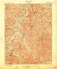
1904 Map of Weston
USGS Topo · Published 1913About this map
The West Fork River carves a winding path through this early twentieth-century landscape, anchoring a series of small settlements and industrial operations across Harrison and Lewis Counties. The Baltimore and Ohio railroad tracks follow the river's contours, connecting the regional center of Weston with northern locales like Jane Lew and West Milford. Industrial activity is evident near the northern edge at the Lewis Lynch Mines, while the Richwood Branch extends the rail network into the surrounding hills.
Find a feature on this map
82 named features on this map. Tap any name to fly to it.
Don’t see what you’re looking for? This feature index may not catch every label — zoom into the map to look around manually.
Map Details
Editions of this 1904 Weston Map
2 editions found
Other maps of this area

1893 · Buckhannon
USGS Topo · 1:125,000

1893 · Sutton
USGS Topo · 1:125,000

1896 · Buckhannon
USGS Topo · 1:125,000

1897 · Buckhannon
USGS Topo · 1:125,000

1902 · Clarksburg
USGS Topo · 1:62,500

1902 · Fairmont
USGS Topo · 1:62,500

1904 · Philippi
USGS Topo · 1:62,500

1904 · Weston
USGS Topo · 1:62,500

1904 · Vadis
USGS Topo · 1:62,500

1905 · Centerpoint
USGS Topo · 1:62,500