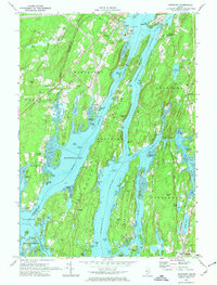
1970 Map of Westport
USGS Topo · Published 1974About this map
Fort Edgecomb stands at the northern tip of Davis Island, overlooking The Eddy and the strategic junction where the Sheepscot River meets the maze of coastal narrows. This 1970 survey records the intricate tidal landscape of Lincoln County, where the massive Westport island is defined by the Back River and Montsweag Bay. The map details a maritime economy transitioning into a mid-century coastal community, evidenced by the Wiscasset Airport and a prominent Powerplant near Cushman Point. Genealogical researchers will find numerous family-named landmarks and burial grounds, including the Tarbox Cem and Knight Cem. The terrain is characterized by complex hydrography, from the turbulent Lower Hell Gate on the Sasanoa River to the sheltered waters of Oven Mouth, illustrating the historical reliance on these waterways for transport and local industry.
Find a feature on this map
113 named features on this map. Tap any name to fly to it.
Don’t see what you’re looking for? This feature index may not catch every label — zoom into the map to look around manually.
Map Details
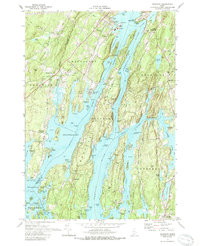
Editions of this 1970 Westport Map
2 editions found
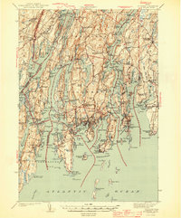
Other maps of this area

1892 · Gardiner
USGS Topo · 1:62,500

1893 · Wiscasset
USGS Topo · 1:62,500

1893 · Boothbay
USGS Topo · 1:62,500

1894 · Bath
USGS Topo · 1:62,500

1920 · Bath
USGS Topo · 1:62,500

1941 · Boothbay
USGS Topo · 1:62,500

1943 · Gardiner
USGS Topo · 1:62,500

1943 · Boothbay
USGS Topo · 1:62,500

1944 · Wiscasset
USGS Topo · 1:62,500
1944 · Boothbay
USGS Topo · 1:62,500