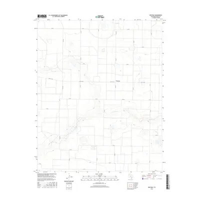
2016 Map of Westway
USGS Topo · Published 2016About this map
Westway sits atop the high plains of the Texas Panhandle, defined by a strictly organized grid of agricultural roads and the meandering path of Tierra Blanca Cr. This landscape is a prime example of the rural infrastructure of Deaf Smith County, where the systematic layout of routes like Co RD MM and Co RD K facilitates large-scale farming and ranching. The primary artery, Ranch Rd 1058, bisects the area, connecting the local population to the surrounding territory. The topography is relatively flat, punctuated only by the depression of the creek and scattered playa lakes that are characteristic of this region. This survey captures the intersection of natural drainage and modern transport, showing how water and roadways dictate the movement of people and resources across this open expanse.
Find a feature on this map
19 named features on this map. Tap any name to fly to it.
Don’t see what you’re looking for? This feature index may not catch every label — zoom into the map to look around manually.
Map Details
Editions of this 2016 Westway Map
This is the sole edition of this map. No revisions or reprints were ever made.
Other maps of this area

1954 · Clovis
USGS Topo · 1:250,000

1958 · Clovis
USGS Topo · 1:250,000

1966 · Friona
USGS Topo · 1:24,000

1966 · Easter
USGS Topo · 1:24,000

1966 · Summerfield
USGS Topo · 1:24,000

1970 · Chalk Hill
USGS Topo · 1:24,000

1970 · Hereford
USGS Topo · 1:24,000

1971 · Westway
USGS Topo · 1:24,000
1971 · Milo Center
USGS Topo · 1:24,000
1971 · Westway NW
USGS Topo · 1:24,000