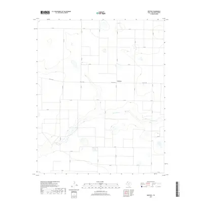
2019 Map of Westway
USGS Topo · Published 2019About this map
Westway anchors this section of Deaf Smith County, situated in a landscape defined by an orderly grid of rural transport routes. The settlement serves as a junction for local travel, with Ranch Rd 1058 passing through the center of the community and connecting it to the surrounding High Plains terrain. The most significant natural feature is Tierra Blanca Cr, which cuts a distinct path through the southern half of the quadrangle, creating a rare break in the otherwise consistent agricultural and ranching layout. The map documents a highly structured road network, from major connectors like Fm 1057 to numerous section-line roads such as Co Rd 9 and Co Rd MM, reflecting the systematic land division of the Texas Panhandle in the early 21st century.
Find a feature on this map
19 named features on this map. Tap any name to fly to it.
Don’t see what you’re looking for? This feature index may not catch every label — zoom into the map to look around manually.
Map Details
Editions of this 2019 Westway Map
This is the sole edition of this map. No revisions or reprints were ever made.
Other maps of this area

1954 · Clovis
USGS Topo · 1:250,000

1958 · Clovis
USGS Topo · 1:250,000

1966 · Friona
USGS Topo · 1:24,000

1966 · Easter
USGS Topo · 1:24,000

1966 · Summerfield
USGS Topo · 1:24,000

1970 · Chalk Hill
USGS Topo · 1:24,000

1970 · Hereford
USGS Topo · 1:24,000

1971 · Westway
USGS Topo · 1:24,000
1971 · Milo Center
USGS Topo · 1:24,000
1971 · Westway NW
USGS Topo · 1:24,000