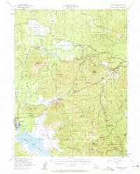
1955 Map of Westwood
USGS Topo · Published 1961About this map
Lassen National Forest and Plumas National Forest meet in this mid-century survey, which reveals a landscape defined by industrial forestry and mountain ranching. The town of Westwood serves as the primary hub, surrounded by logging infrastructure including an old railroad grade and active lines of the Southern Pacific and Western Pacific railroads. Distinctive local landmarks like the Westwood Cemetery, Coppervale Guard Station, and several family-named outposts such as Bunnel Ranch and Willard Ranch are clearly documented.
Find a feature on this map
59 named features on this map. Tap any name to fly to it.
Don’t see what you’re looking for? This feature index may not catch every label — zoom into the map to look around manually.
Map Details
Editions of this 1955 Westwood Map
3 editions found

Other maps of this area

1886 · Honey Lake
USGS Topo · 1:250,000

1886 · Lassen Peak
USGS Topo · 1:250,000

1891 · Honey Lake
USGS Topo · 1:250,000

1892 · Lassen Peak
USGS Topo · 1:250,000

1893 · Honey Lake
USGS Topo · 1:250,000

1894 · Lassen Peak
USGS Topo · 1:250,000

1939 · Halls Flat
USGS Topo · 1:125,000

1950 · Kettle Rock
USGS Topo · 1:62,500

1950 · Greenville
USGS Topo · 1:62,500

1954 · Susanville
USGS Topo · 1:62,500