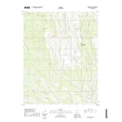
2019 Map of Wetherill Mesa
USGS Topo · Published 2019About this map
Mesa Verde National Park anchors this 2019 survey, showcasing a landscape of high mesas and deep-cut canyons. The central feature, Wetherill Mesa, is accessed via the Wetherill Mesa Rd and contains archaeological and recreational corridors including the Long House Loop Trail. To the east, Long Mesa and Chapin Mesa parallel this formation, separated by the complex drainage systems of Wickiup Canyon and Bobcat Canyon. This modern record illustrates the preservation of ancient sites through labels like Pictograph Point and the Far View Sites Trail. Water sources in this arid environment are specifically identified at Horse Springs and Rock Springs, which were critical nodes for early inhabitants. The topographic relief is defined by prominent landmarks such as Pulpit Rock on the North Rim and the extensive Eagle Eye Mesa to the south.
Find a feature on this map
48 named features on this map. Tap any name to fly to it.
Don’t see what you’re looking for? This feature index may not catch every label — zoom into the map to look around manually.
Map Details
Editions of this 2019 Wetherill Mesa Map
This is the sole edition of this map. No revisions or reprints were ever made.
Other maps of this area

1912 · Soda Canyon
USGS Topo · 1:62,500

1915 · Soda Canyon
USGS Topo · 1:62,500

1956 · Cortez
USGS Topo · 1:250,000

1958 · Cortez SW
USGS Topo · 1:24,000

1958 · Cortez
USGS Topo · 1:250,000

1959 · Cortez
USGS Topo · 1:250,000

1962 · Cortez
USGS Topo · 1:250,000

1965 · Cortez
USGS Topo · 1:24,000
1965 · Point Lookout
USGS Topo · 1:24,000

1966 · Cortez
USGS Topo · 1:250,000