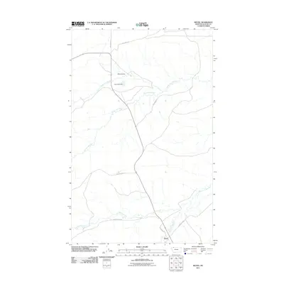
2011 Map of Wetzel
USGS Topo · Published 2011About this map
The confluence of prairie hydrology and ranching infrastructure defines this 2011 survey of Wetzel in Glacier County. The landscape is structured by the divergent branches of the Milk River, including the Middle Fork, Dry Fork, and South Fork. Significant water management is evident at Pistol Bullet Dam, which sits just south of Davis Coulee. The transportation network reflects the remote, utilitarian nature of the region, anchored by historical pathways such as Whiskey Gap Rd and Mcgovern Trl. This area illustrates the persistence of wide-open ranchland in northern Montana, where named routes like Burd Ranch Rd and Saebo Ranch Rd indicate long-standing land holdings. The mapping of Livermore Truck Trl and Livermore Creek Rd near Livermore Creek further highlights the local reliance on established backcountry access for livestock and land management.
Find a feature on this map
14 named features on this map. Tap any name to fly to it.
Don’t see what you’re looking for? This feature index may not catch every label — zoom into the map to look around manually.
Map Details
Editions of this 2011 Wetzel Map
This is the sole edition of this map. No revisions or reprints were ever made.
Other maps of this area

1901 · Browning
USGS Topo · 1:125,000

1903 · Browning
USGS Topo · 1:125,000

1960 · Cut Bank
USGS Topo · 1:250,000

1963 · Cut Bank
USGS Topo · 1:250,000

1964 · Cut Bank
USGS Topo · 1:250,000

1968 · Josephine
USGS Topo · 1:24,000

1968 · Hoodoo Hill
USGS Topo · 1:24,000
1968 · Duck Lake
USGS Topo · 1:24,000

1968 · Browning NE
USGS Topo · 1:24,000
1968 · Emigrant Gap
USGS Topo · 1:24,000