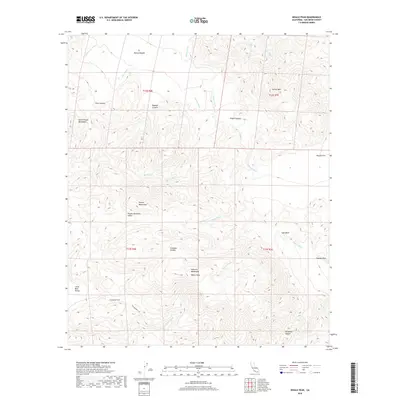
2018 Map of Whale Peak
USGS Topo · Published 2018About this map
Whale Peak stands as the central landmark of this high-desert region, anchoring the rugged terrain between the Vallecito Mountains and the Pinyon Mountains. The landscape is defined by a dense network of ephemeral watercourses including Chuckwalla Wash, Mine Wash, and Nolina Wash, which flow from the heights toward the alluvial plains of Mescal Bajada and Harper Flat. Cultural history is prominently represented by the Pictograph Trail, which winds through the southern reaches of Pinyon Mountain Valley near Little Blair Valley. This area serves as a significant intersection of arid topography and ancient pathways, where features like Smuggler Canyon and Bighorn Canyon suggest a history of both natural wildlife corridors and human passage through the San Diego County backcountry.
Find a feature on this map
32 named features on this map. Tap any name to fly to it.
Don’t see what you’re looking for? This feature index may not catch every label — zoom into the map to look around manually.
Map Details
Editions of this 2018 Whale Peak Map
This is the sole edition of this map. No revisions or reprints were ever made.
Other maps of this area

1931 · Vallecito
USGS Topo · 1:125,000

1931 · Carrizo
USGS Topo · 1:125,000

1939 · Borrego
USGS Topo · 1:62,500

1942 · Barrel Spring
USGS Topo · 1:62,500

1942 · Borego
USGS Topo · 1:62,500

1942 · Carrizo Mtn
USGS Topo · 1:62,500

1942 · Cuyapaipe
USGS Topo · 1:62,500

1943 · Vallecito
USGS Topo · 1:125,000

1947 · Santa Ana
USGS Topo · 1:250,000
1947 · Barrel Spring
USGS Topo · 1:62,500