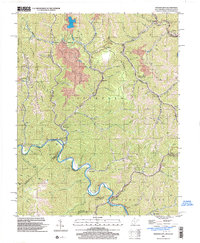
2001 Map of Wharncliffe
USGS Topo · Published 2003About this map
The Tug Fork river defines the winding border between West Virginia and Kentucky in this early 21st-century topographic study of Mingo County. The rugged terrain of Stafford Mountain and Glen Alum Mountain is punctuated by narrow valleys where settlements like Wharncliffe and War Eagle are situated. The heavy industrial footprint of the Central Appalachian coal fields is evident in the presence of a large Strip Mine and a Tipple near Glen Alum, connected by a network of conveyors and the Norfolk and Western railroad. Local community life is rooted in family and faith, marked by sites such as Hardy Union Ch, Ben Creek Sch, and the Wyoming City (Mohawk PO) post office. Notable geographic landmarks like Twisted Gun Gap provide passage through the steep ridges that separate the numerous creek branches feeding into the main river system.
Find a feature on this map
63 named features on this map. Tap any name to fly to it.
Don’t see what you’re looking for? This feature index may not catch every label — zoom into the map to look around manually.
Map Details
Editions of this 2001 Wharncliffe Map
This is the sole edition of this map. No revisions or reprints were ever made.
Other maps of this area

1886 · Grundy
USGS Topo · 1:125,000

1887 · Warfield
USGS Topo · 1:125,000

1890 · Grundy
USGS Topo · 1:125,000

1891 · Tazewell
USGS Topo · 1:125,000

1891 · Oceana
USGS Topo · 1:125,000

1891 · Warfield
USGS Topo · 1:125,000

1892 · Grundy
USGS Topo · 1:125,000

1893 · Oceana
USGS Topo · 1:125,000

1895 · Tazewell
USGS Topo · 1:125,000

1897 · Tazewell
USGS Topo · 1:125,000