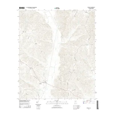
2014 Map of Whatley
USGS Topo · Published 2014About this map
Whatley anchors the southern portion of this Clarke County landscape, where the local road network converges near Whatley Cem and Davis Cem. The terrain is defined by a dense system of creek valleys, most notably Bassett Cr, which runs centrally through the quadrangle. Smaller tributaries like Graveyard Br, Pole Bridge Br, and James Cr carve through the wooded hills, creating a fragmented topography that dictated the placement of early settlements and family cemeteries.
Find a feature on this map
47 named features on this map. Tap any name to fly to it.
Don’t see what you’re looking for? This feature index may not catch every label — zoom into the map to look around manually.
Map Details
Editions of this 2014 Whatley Map
This is the sole edition of this map. No revisions or reprints were ever made.
Other maps of this area

1953 · Andalusia
USGS Topo · 1:250,000

1957 · Andalusia
USGS Topo · 1:250,000

1972 · Whatley
USGS Topo · 1:24,000

1972 · Claiborne
USGS Topo · 1:24,000

1972 · Suggsville
USGS Topo · 1:24,000

1972 · Chance
USGS Topo · 1:24,000

1973 · Fulton East
USGS Topo · 1:24,000

1973 · Lower Peach Tree
USGS Topo · 1:24,000
1978 · Grove Hill
USGS Topo · 1:24,000
1978 · Fulton West
USGS Topo · 1:24,000