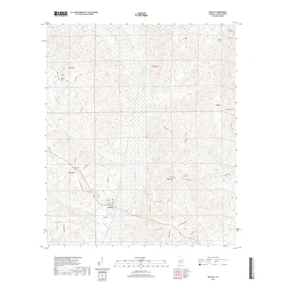
2018 Map of Whatley
USGS Topo · Published 2018About this map
Whatley serves as a central hub for this portion of Clarke County, where rural life is defined by its network of family cemeteries and winding creeks. The landscape is characterized by the drainage basins of Bassett Creek and Pigeon Creek, interspersed with small settlements such as Orange Hill and Vashti. Genealogical value is high throughout the quadrangle, with numerous burial sites including Salem Cem, Gates Cem, and Davis Cem situated near the local road networks. Local history is etched into the names of the thoroughfares, from Fort Sin Quefield Rd to Skipper Raines Rd, tracing the paths of early Alabama residents through the dense terrain between Lake Harrington and the many branches of Pole Bridge Branch.
Find a feature on this map
52 named features on this map. Tap any name to fly to it.
Don’t see what you’re looking for? This feature index may not catch every label — zoom into the map to look around manually.
Map Details
Editions of this 2018 Whatley Map
This is the sole edition of this map. No revisions or reprints were ever made.
Other maps of this area

1953 · Andalusia
USGS Topo · 1:250,000

1957 · Andalusia
USGS Topo · 1:250,000

1972 · Whatley
USGS Topo · 1:24,000

1972 · Claiborne
USGS Topo · 1:24,000

1972 · Suggsville
USGS Topo · 1:24,000

1972 · Chance
USGS Topo · 1:24,000

1973 · Fulton East
USGS Topo · 1:24,000

1973 · Lower Peach Tree
USGS Topo · 1:24,000
1978 · Grove Hill
USGS Topo · 1:24,000
1978 · Fulton West
USGS Topo · 1:24,000