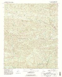
1991 Map of Wheeler Springs
USGS Topo · Published 1991About this map
Wheeler Springs serves as a small human footprint in the expansive wilderness of the Los Padres National Forest during the early 1990s. The landscape is defined by the dramatic relief of Pine Mountain and the deep cuts of the Sespe Creek drainage. The map reveals a network of high-elevation campsites and campgrounds such as Holiday Group Campground and Wheeler Gorge Campground, which cluster near the transition from the Wheeler Gorge to the higher ridges. This area, managed for public use and fire protection, includes the Wheeler Gorge Fire Station situated along the critical transit corridor of Highway 33. Water remains the primary architect of this terrain, with the North Fork Matilija Creek and its various tributaries, like Upper North Fork Matilija Creek, carving through the steep topography to create landmarks like Chorro Falls and the Sespe Gorge.
Find a feature on this map
36 named features on this map. Tap any name to fly to it.
Don’t see what you’re looking for? This feature index may not catch every label — zoom into the map to look around manually.
Map Details
Editions of this 1991 Wheeler Springs Map
2 editions found
Other maps of this area

1903 · Santa Paula
USGS Topo · 1:62,500

1903 · Mt. Pinos
USGS Topo · 1:125,000

1904 · Ventura
USGS Topo · 1:62,500

1941 · Ventura
USGS Topo · 1:62,500

1942 · Santa Paula
USGS Topo · 1:62,500

1942 · Wheeler Springs
USGS Topo · 1:24,000

1943 · Rancho Nuevo Creek
USGS Topo · 1:24,000

1943 · Old Man Mountain
USGS Topo · 1:24,000

1943 · San Guillermo
USGS Topo · 1:24,000

1943 · Lion Canyon
USGS Topo · 1:24,000