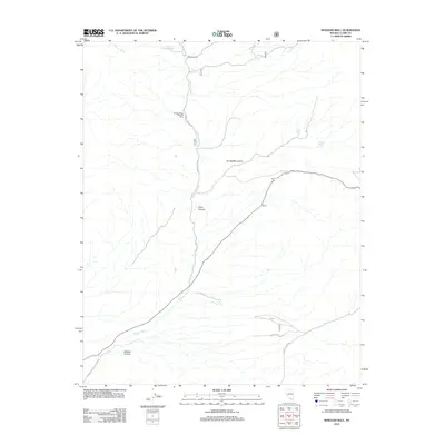
2012 Map of Wheeler Well
USGS Topo · Published 2012About this map
Spring Mountains terrain dominates this Nevada landscape, where high-altitude resources once supported early frontier industry. The presence of Charcoal Kilns near the north-south corridor of Wheeler Pass Rd points to the area's historical connection to mining and fuel production, requiring the burning of local timber in stone structures to support ore processing. Water sources remain the primary landmarks in this arid environment, with Wheeler Well serving as a central point of interest alongside Buck Spring and Rosebud Spring. Deep drainage systems like Clark Canyon and Wallace Canyon dictate the path of local travel, etched by the seasonal flow of Wheeler Wash. The map records a network of secondary routes including Wallace Canyon Rd and Clark Canyon Rd, which follow the natural contours of the mountain slopes.
Find a feature on this map
12 named features on this map. Tap any name to fly to it.
Don’t see what you’re looking for? This feature index may not catch every label — zoom into the map to look around manually.
Map Details
Editions of this 2012 Wheeler Well Map
This is the sole edition of this map. No revisions or reprints were ever made.
Other maps of this area

1907 · Las Vegas
USGS Topo · 1:250,000

1908 · Las Vegas
USGS Topo · 1:250,000

1954 · Las Vegas
USGS Topo · 1:250,000

1957 · Las Vegas
USGS Topo · 1:250,000

1957 · Mt. Stirling
USGS Topo · 1:62,500

1957 · Charleston Peak
USGS Topo · 1:62,500

1957 · Mountain Springs
USGS Topo · 1:62,500
1958 · Pahrump
USGS Topo · 1:62,500

1959 · Las Vegas
USGS Topo · 1:250,000

1962 · Las Vegas
USGS Topo · 1:250,000