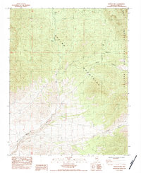
1984 Map of Wheeler Well
USGS Topo · Published 1984About this map
Charcoal Kilns stand as a physical reminder of early industrial activity in the high elevations of the Spring Mountains on this 1980s-era survey. The map documents a landscape defined by scarce water sources and rugged topography, where the Wheeler Pass Road serves as a primary artery through the Toiyabe National Forest. The presence of several vital water points, such as Wheeler Well and Buck Spring, underscores the strategic importance of these locations for travelers crossing the range between Clark Canyon and Wallace Canyon. Near the seasonal drainage of Wheeler Wash, the label for Rosebud Spring (Dry) illustrates the arid conditions of the terrain during this period. This provisional survey captures the intersection of natural resource management and historical land use in a transition zone of the Great Basin.
Find a feature on this map
11 named features on this map. Tap any name to fly to it.
Don’t see what you’re looking for? This feature index may not catch every label — zoom into the map to look around manually.
Map Details
Editions of this 1984 Wheeler Well Map
This is the sole edition of this map. No revisions or reprints were ever made.
Other maps of this area

1907 · Las Vegas
USGS Topo · 1:250,000

1908 · Las Vegas
USGS Topo · 1:250,000

1954 · Las Vegas
USGS Topo · 1:250,000

1957 · Las Vegas
USGS Topo · 1:250,000

1957 · Mt. Stirling
USGS Topo · 1:62,500

1957 · Charleston Peak
USGS Topo · 1:62,500

1957 · Mountain Springs
USGS Topo · 1:62,500
1958 · Pahrump
USGS Topo · 1:62,500

1959 · Las Vegas
USGS Topo · 1:250,000

1962 · Las Vegas
USGS Topo · 1:250,000