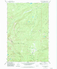
1974 Map of Whetstone Ridge
USGS Topo · Published 1977About this map
Montana Prince Mine and O'Brien Mine anchor a cluster of mining prospects in the high timber of the Bitterroot and Deerlodge national forests. This mid-1970s topographic study captures the drainage network of Rock Creek and its many tributaries, including Moose Meadow Cr and Falls Creek. The landscape is defined by its verticality, rising from the Frogpond Basin to the prominent heights of Table Mountain and Whetstone Ridge. The map details a complex web of Pack Trails that served as the primary infrastructure for prospectors and foresters alike, connecting remote alpine waters such as Medicine Lake, Green Canyon Lake, and Little Fish Lake. This survey illustrates the era's focus on resource extraction and land management along the boundary between Granite and Ravalli counties.
Find a feature on this map
36 named features on this map. Tap any name to fly to it.
Don’t see what you’re looking for? This feature index may not catch every label — zoom into the map to look around manually.
Map Details
Editions of this 1974 Whetstone Ridge Map
This is the sole edition of this map. No revisions or reprints were ever made.
Other maps of this area

1909 · Sapphire
USGS Topo · 1:125,000

1947 · Butte
USGS Topo · 1:250,000

1955 · Dillon
USGS Topo · 1:250,000

1957 · Dillon
USGS Topo · 1:250,000

1958 · Butte
USGS Topo · 1:250,000

1958 · Dillon
USGS Topo · 1:250,000

1960 · Butte
USGS Topo · 1:250,000

1962 · Butte
USGS Topo · 1:250,000

1962 · Dillon
USGS Topo · 1:250,000

1965 · Dillon
USGS Topo · 1:250,000