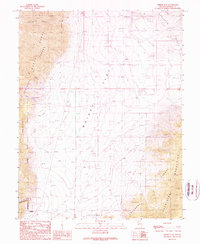
1989 Map of Whisky Flat
USGS Topo · Published 1989About this map
Whisky Flat occupies the central basin of this Mineral County landscape, serving as a geographic anchor between the high peaks of the Wassuk Range to the west and the Garfield Hills to the east. This 1980s survey highlights a desert environment defined by critical water sources like Whisky Spring and Powell Canyon Spring, which are essential landmarks in an otherwise arid expanse. The southern reaches of the map are defined by the Excelsior Mountains and the northern boundary of the Toiyabe National Forest. Human activity is concentrated along the basin floor and canyon mouths, indicated by numerous Prospect sites and Gravel Pits, while the southwestern corner is marked by a Restricted Area, signaling military or government land use common in the Nevada desert during this era.
Find a feature on this map
22 named features on this map. Tap any name to fly to it.
Don’t see what you’re looking for? This feature index may not catch every label — zoom into the map to look around manually.
Map Details
Editions of this 1989 Whisky Flat Map
This is the sole edition of this map. No revisions or reprints were ever made.
Other maps of this area

1909 · Hawthorne
USGS Topo · 1:250,000

1911 · Hawthorne
USGS Topo · 1:250,000

1915 · Hawthorne
USGS Topo · 1:250,000

1948 · Walker Lake
USGS Topo · 1:250,000

1955 · Powell Mtn
USGS Topo · 1:62,500

1957 · Walker Lake
USGS Topo · 1:250,000

1958 · Huntoon Valley
USGS Topo · 1:62,500

1962 · Walker Lake
USGS Topo · 1:250,000

1964 · Walker Lake
USGS Topo · 1:250,000

1967 · Pamlico
USGS Topo · 1:24,000