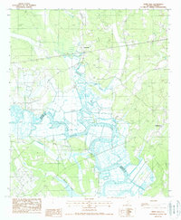
1988 Map of White Hall
USGS Topo · Published 1988About this map
The Combahee River defines this Lowcountry landscape along the boundary of Colleton and Beaufort counties. This late-twentieth-century survey documents a coastal environment heavily managed by a network of drainage and flood control, indicated by numerous Levee systems and an extensive road on levee network. Settlement is concentrated at White Hall and Hickory Hill, with the historic Bonny Hall situated near the riverbanks. The importance of water access and telecommunications to the area is clear through the presence of a Public Boat Ramp, a private Landing Strip, and the WJWJ Radio Tower. The intricate winding paths of Cuckolds Creek, Folly Creek, and Branford Creek illustrate the tidal complexity of the South Carolina coast, where land and water are inextricably linked by both nature and engineering.
Find a feature on this map
16 named features on this map. Tap any name to fly to it.
Don’t see what you’re looking for? This feature index may not catch every label — zoom into the map to look around manually.
Map Details
Editions of this 1988 White Hall Map
This is the sole edition of this map. No revisions or reprints were ever made.
Other maps of this area

1918 · Walterboro
USGS Topo · 1:62,500

1918 · Green Pond
USGS Topo · 1:62,500

1918 · Yemassee
USGS Topo · 1:62,500

1919 · Cummings
USGS Topo · 1:62,500

1943 · Yemassee
USGS Topo · 1:62,500

1943 · Green Pond
USGS Topo · 1:62,500

1943 · Cummings
USGS Topo · 1:62,500

1943 · Walterboro
USGS Topo · 1:62,500

1947 · Savannah
USGS Topo · 1:250,000

1948 · Savannah
USGS Topo · 1:250,000