
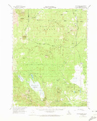
1962 Map of White Horse
USGS Topo · Published 1964About this map
Modoc State Game Refuge encompasses a significant portion of this high-altitude landscape, where the volcanic geology of the Great Lava Reef and Lava Rim dictates the pattern of water and transit. The timber and ranching economy of the early 1960s is evidenced by the network of Logging Roads and the presence of Long Bell Station. Water management is central to the area's utility, with numerous named waterholes like Crystal Waterholes and Ben Eberli Waterhole supporting livestock across the Big Valley Mountains.
Find a feature on this map
72 named features on this map. Tap any name to fly to it.
Don’t see what you’re looking for? This feature index may not catch every label — zoom into the map to look around manually.
Map Details
Editions of this 1962 White Horse Map
2 editions found
Other maps of this area

1886 · Modoc Lava Bed
USGS Topo · 1:250,000

1892 · Modoc Lava-Bed
USGS Topo · 1:250,000

1932 · Bartle
USGS Topo · 1:96,000

1939 · Bartle
USGS Topo · 1:125,000

1952 · Timber Mountain
USGS Topo · 1:62,500

1952 · Hackamore
USGS Topo · 1:62,500

1952 · Medicine Lake
USGS Topo · 1:62,500

1954 · Alturas
USGS Topo · 1:250,000

1958 · Alturas
USGS Topo · 1:250,000

1961 · Hambone
USGS Topo · 1:62,500