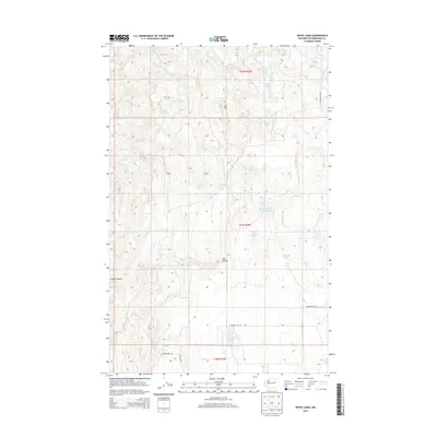
2014 Map of White Lakes
USGS Topo · Published 2014About this map
White Lakes anchor this high-plateau landscape in Okanogan County, where a series of internally drained basins and springs define the local geography. The area's hydrology is complex, featuring a high density of small water bodies such as Lake Thirty-Two, Island Lake, and the unofficially named McDonald Lake. The presence of Alkali Pond and Mud Spring indicates a characteristic high-desert or semi-arid environment where mineral-rich water sources were essential for the region's early cattle ranching and land use.
Find a feature on this map
22 named features on this map. Tap any name to fly to it.
Don’t see what you’re looking for? This feature index may not catch every label — zoom into the map to look around manually.
Map Details
Editions of this 2014 White Lakes Map
This is the sole edition of this map. No revisions or reprints were ever made.
Other maps of this area

1905 · Okanogan
USGS Topo · 1:125,000

1950 · Boot Mtn
USGS Topo · 1:62,500

1953 · Omak Lake
USGS Topo · 1:62,500

1954 · Okanogan
USGS Topo · 1:250,000

1957 · Okanogan
USGS Topo · 1:62,500

1957 · Bridgeport
USGS Topo · 1:62,500

1958 · Okanogan
USGS Topo · 1:250,000

1980 · Okanogan
USGS Topo · 1:24,000
1980 · Bridgeport Point
USGS Topo · 1:24,000
1980 · Joe Lake
USGS Topo · 1:24,000